Vildmark: Navigation and mapping tailored for Swedish backcountry
Vildmark, developed by Vildmark.app, is an Android navigation app built for outdoor travel in the Swedish wilderness. It supplies map-based navigation, route recording and live position tracking to support field decision-making on remote trips. The app collects tools for offline map access, searchable place listings and compass-assisted orientation so users can manage routes without constant connectivity. Its audience is hikers, hunters and campers who need dependable map detail and trip records when operating far from mobile coverage.
Integration of official Swedish mapping improves positional trust
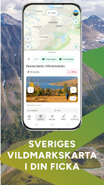
Vildmark sources its topographical layers directly from Lantmäteriet, the national mapping authority, which provides high-resolution contouring and land classification for route planning. Points of interest are presented as searchable map entries, including shelters, cabins and prepared fireplaces. That mapped infrastructure gives field users a documented reference for shelter and resupply planning rather than relying on informal notes.
Position tracking and orientation support practical route management
GPS tracking records active routes and saves breadcrumb trails for post-trip review, while an on-screen compass helps with immediate orientation on complex terrain. Continuous route recording during a session creates paths that users can inspect later to repeat itineraries or share simple navigation references. Saved tracks assist group planning and act as a lightweight trip log for later analysis.
Designed for offline use and modern Android devices in remote areas
The app lets users prepare for low-connectivity conditions by downloading specific map sections in advance, keeping tiles available when cellular reception is absent. Installation requires a current Android release for optimal performance, a platform requirement noted by the developer. Prepared downloads reduce dependence on signal, so extended treks and multi-day itineraries remain navigable without immediate network access.
Geared toward Swedish backcountry users but has language and scope limits
Vildmark targets hikers, hunters and campers focused on Swedish terrain; the developer's specialist approach concentrates the tool on navigation rather than social features or broad international coverage. Many place names and specific entries remain in Swedish, which can require extra local knowledge for non-Swedish speakers. Users are responsible for ensuring their use complies with applicable platform terms and local regulations in regulated areas.
Vildmark is a purpose-built choice for prepared outdoor users
Vildmark suits outdoor users who prioritize reliable, navigation-focused mapping for trips in Swedish backcountry and accept a specialist, single-country focus. Users should confirm that their use aligns with relevant platform terms and local rules before relying on the app in regulated areas. For those priorities, the app rewards careful pre-trip preparation and map-based planning rather than casual, on-the-fly exploration.
Pros
Uses Lantmäteriet topographical maps for authoritative Swedish terrain detail
Offline map downloads keep tiles available without cellular reception
POI database lists shelters, cabins, fireplaces and natural landmarks
Cons
Place names and entries often remain in Swedish, challenging some users
Android requirement limits use to modern Android devices
Specialist focus means limited appeal outside Swedish backcountry navigation
Laws concerning the use of this software vary from country to country. We do not encourage or condone the use of this program if it is in violation of these laws. Softonic may receive a referral fee if you click or buy any of the products featured here.